|
| |
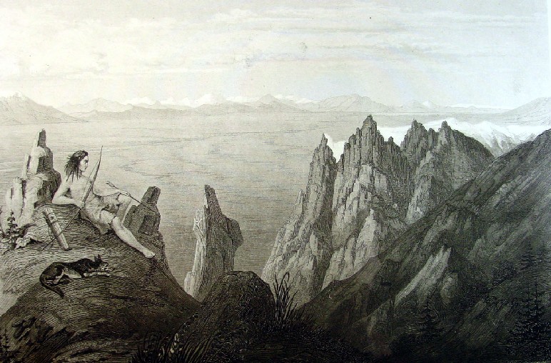
Original 1850s Native American Indian Print
Indian and Dog Survey Majesty of Franklin
Valley From Mountain Top
Its not in color, its not a lithograph and it was
not published in the 1850s like all the rest, but this steel engraving by
Friedrich Wilhelm von Egloffstein is such a romantic vision of an Indian in the wild
that it had to go first. This engraving was published in Vol. XI of the "Reports
of Explorations and Survey to Ascertain the Most Practicable and Economical
Route for a Railroad from the Mississippi River to the Pacific Ocean."
In "Prints of the West: Library of Congress
Classics" by Ron Tyler (Golden, CO, 1994) the author says,
Perhaps the best landscapist of all the
expeditionary artists was Egloffstein, who accompanied Beckwith on the
completion of Gunnison's survey of the thirty - eighth parallel...His visa
Franklin Valley is one of the most Romantic images in the entire work, with the
jagged peaks of the Humboldt chain in the foreground and the vast and untouched
terrain of the valley below. An Indian reclines on a rock in the left
foreground, bow and arrow in hand and dog lying nearby, an unmistakable
reference to an allegorical god of nature overseeing his domain. But the
expression that the warrior wears is also recognizable: he is either completely
lost in a Romantic and introspective daydream, or he is depressed by the change
this is overwhelming his country.
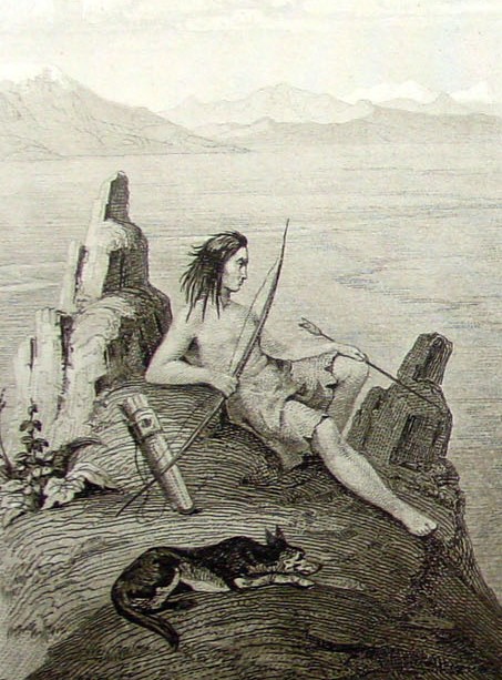
Here a close-up of the Indian and his dog or
coyote.
One web site giving the history of the Central
Pacific Railroad gives
a full explanation of this print at this web location:
Valley of Franklin River and Franklin Lake
May 24th at 10am, from a spur of the Humboldt Mts (now called Ruby Mts)
Antelope Bute at left background. Franklin River and Lake in the middle-ground.
There is a coyote and Native American in the left foreground.
Nevada
Print Type: Single-sided Steel Engraving
printed on heavy paper. A print produced by hand carving the lines of the image
into a metal plate (steel, or copper that is later steel plated) with a tool
called a burin. The valleys produced by the carving are then filled with ink,
and a dampened sheet of paper is pressed onto the metal plate. The ink is
transferred to the paper, producing the print. This type of engraving was
introduced in the 15th century and is a form of intaglio printing.
Print Date: 1861.
Print Title: Franklin Valley.
Artist: Friedrich Wilhelm von Egloffstein (1824-1885/1898). Topographical
draftsman who was born in Prussia. Egloffstein served as artist and topographer
to several of the exploring expeditions of the territory west of the Mississippi
River. He served with the 103rd Regiment, New York Volunteers during the Civil
War, attaining the rank of Brigadier General. Egloffstein also was known for
developing the first commercial half-tone process of engraving in the United
States which he described in a book published in 1857. (For more information
see: Hanson, David A. (1993) Baron Frederick Wilhelm von Egloffstein: Inventor
of the First Commercial Halftone Process in America. Printing History, 15, No.
1, 12-24.) Prepared by C. Schumann from F.W. Egloffstein.
Engraver: Selmar Siebert's Engraving and Printing Establishment,
Washington, D.C..
Source: Reports of Explorations and Surveys, to Ascertain the Most
Practicable and Economical Route for a Railroad from the Mississippi River to
the Pacific Ocean. Made under the Direction of the Secretary of War, in 1853-56.
According to Acts of Congress of March 3, 1853, May 31, 1854, and August 5,
1854. Volume XI. Washington: George W. Bowman, Printer, 1861.
Image Size: 8 7/8 x 5 7/8 inches.
Total Size including margins: 11 3/8 x 8 3/8 inches.
History: In 1853, the U.S. Congress authorized the Corps of Topographic
Engineers to undertake a survey of potential rail routes between the Mississippi
River and the Pacific Ocean. This print is an illustration from the report of
the survey at the 41st parallel under the leadership of Lt. Edward G. Beckwith,
in the region between the Green River Valley and the Sacramento River Valley,
conducted in 1854. Beckwith's survey was a continuation of the survey at the
38th and 39th parallels headed by Captain John Gunnison, which was terminated in
October, 1853 after Gunnison, artist Richard Kern and others were killed in what
is now Utah. The precisely detailed drawings of Egloffstein were coordinated
with the maps produced.
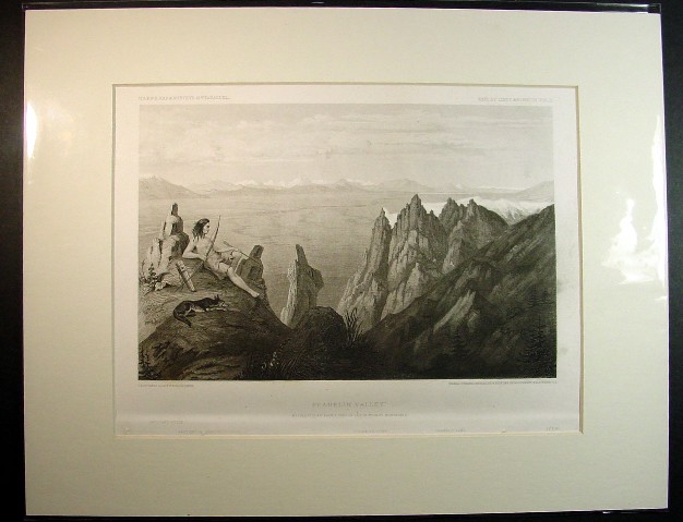
This is how the print looks matted to a standard
frame size of 11 x 14" and enclosed in a protective clear plastic bag. There is
a a little soiling on the right lower margin as shown and some binding holes at
the very bottom of the exposed print that can be matted out but it would cover
some of the text that identifies some of the distant topographical features. The
glare in the picture is the reflection off the clear plastic covering.
Price: SOLD
|